Gravity
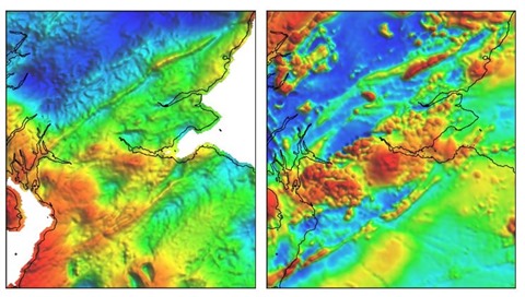
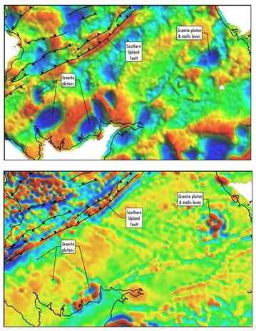
Gravity is a high-precision method for measuring density contrasts that may relate to economic resources buried at depth. It is applicable for mineral exploration, geothermal exploration, and oil and gas exploration.
Gravity survey is used as supplementary to raw materials exploration and as reconnaissance one to design seismic works. Application of gravity method is especially recommended in the case of rock complexes screening seismic energy, as the screening or attenuating layers are transparent for gravity field. Qualitative and quantitative interpretation of gravity data provides information on location, density and depth of geological structures. Maps of gravity anomalies indicate location and dimensions of the structures and extent of tectonic zones.
TANA is fully experienced in performing designing, processing, interpretation, inversion and consulting services on Gravity projects.
The shape of a particular gravity anomaly is usually indicative of the dip and depth extent of a geologic unit if there is a significant density contrast with the surrounding rock units.
Magnetic
Magnetic is an effective technique for mapping geologic structure, geology and mineralization in grassroots mineral exploration. It may also be used in combination with other geophysical methods in geothermal exploration, and oil and gas exploration.
The Earth's magnetic field is known as a dipole – consisting of two alignments of magnetic poles. Within the earth, alignments of magnetic minerals, primarily magnetite, affect the amplitude and direction of the measured magnetic field – resulting in a very useful regime for detecting large or small variations that may reflect the geology, attitude and structural components in resource exploration.
TANA is fully experienced to conduct, process and interpret magnetic surveys from either reconnaissance or local surveys based on its extensive experience with magnetic throughout its history.
The role of Magnetics has subsequently been extended to include mapping of alteration zones, lithologic boundaries, and orientation of geologic targets (including shape, attitude, etc.). Magnetic data can also be extremely useful for integrating with other earth science data as well as using data to guide the design and planning of further ground geophysical surveys.
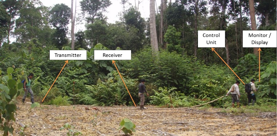
Magnetotelluric (MT)
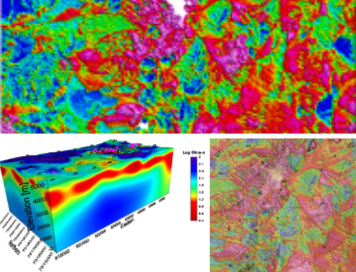
Magnetotelluric (MT) is a passive surface geophysical method used to determine the electrical resistivity of the subsurface to great depth. It is effective for mapping conductive zones, as well as deep-seated structures. It is applicable for mineral exploration, geothermal exploration, and oil & gas exploration.
TANA delivers safe and high-quality data designing, processing, inversion, interpretation and consulting services on a custom basis to meet the needs of clients' specific projects.
MT measurements are flexible, low-impact ground geophysical methods employed to produce 2D and 3D electrical resistivity earth models. MT has particular applicability for reconnaissance in advance of seismic surveys and to provide electrical resistivity and geometrical information to enhance seismic interpretation, particularly in terrains where seismic data quality has been degraded. This is then interpreted in terms of lithology. To transform the impedances to the resistivity distribution within the earth, we use 2D or 3D inversion technique.
Ground Penetrating Radar
GPR is a technique where experience and geophysical expertise is required to process and interpret GPR survey data correctly. Distinct PAS 128 utility quality levels are assigned to post-processed utility locations to reflect the resulting improvement in data interpretation and utility detection. TANA’s geophysicists are experienced GPR data processors. We provide basic to advanced GPR post-processing as standard to improve target object detection and survey interpretation.
- an accurate, fast and high-resolution geophysical technique for subsurface investigation.
- non-invasive, non-destructive and completely safe.
- the only non-intrusive method capable of accurately locating non-metallic subsurface features and utilities (eg. clay, concrete, fibreglass, PVC conduits or fibre-optic cables).
- a geophysical surveying technique based on transmitting pulsed electromagnetic (EM) energy into the subsurface and measuring the strength of the reflected energy.
- successful where a sufficient contrast in material properties (dielectric permittivity) between a buried target and its surroundings exists.
- used by Scantech to detect and map buried pipes, cables, structural reinforcement, voids, disturbed ground, material degradation, subsurface layers and buried objects.
- acquired using transmitting and receiving antennae which can be mounted on a cart, skid plate or vehicle, or can be hand-held.
- a technique which requires qualified and experienced personnel to acquire high quality survey data and geophysical expertise to process and interpret the results.